
What changed in 2026—and why dates matter
The Icelandic Tourist Board's notice of 24 February 2026 reported erosion beneath the viewing platform and two safety signs. A map sign had collapsed and an illuminated warning sign was removed because its undermined foundations posed a risk. The notice directed visitors to remain on the upper beach ridge and said the columns could not be reached. It also recorded that the parking, restaurant and restrooms were open at that time. Tourist Board erosion notice.
A further Tourist Board update on 6 March discussed temporary measures, a lower area of sand forming again and the need to consult the wave forecast while lighting equipment was not active. That is evidence of a changing situation, not a timeless description of the site. Neither notice allows this publication to certify the exact state of every sign or structure months later. March update, in Icelandic.
This chronology helps explain why search results can appear to disagree. A tourism article saying the destination remains worth visiting may have been written before another episode of erosion. An old practical guide may retain a route description because its photographs and text have not been revised. Even a recently crawled page can contain older advice. Check the date of the information itself, not merely the date a search engine last found it.
Separate three questions when reading an update: can vehicles reach the facilities, which visitor area is accessible, and what activities are permitted there? “Open” may answer the first without answering the other two. A café operating normally does not establish that a beach route is available. A viewpoint being accessible does not make a walk beneath a cliff part of the same permission.
For your own plan, keep the latest official access page easy to find and revisit it near departure. A saved screenshot is useful for understanding what was said at one moment, but it should not become an argument against a newer sign or a staff instruction. The correct response to a changed coast is to update the plan, not search for an older description that permits the photograph you wanted.
Volcanic construction, marine editing
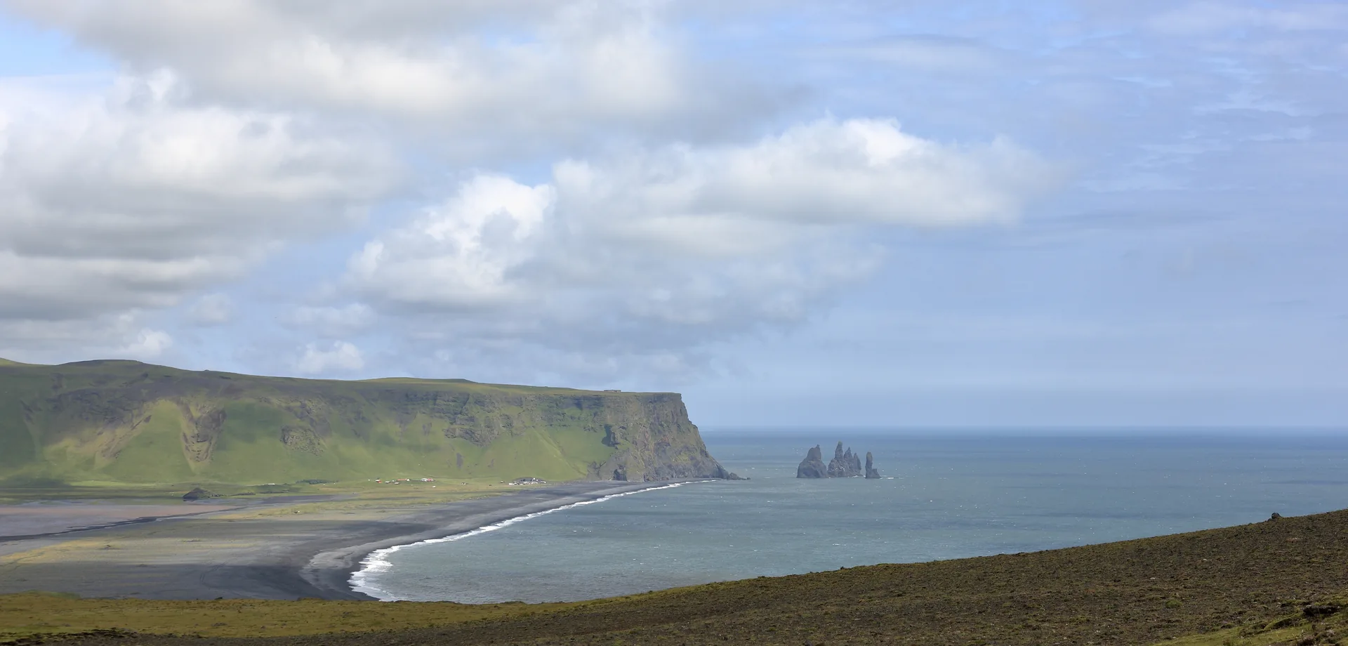
Reynisfjall, the mountain beside the beach, belongs to the Katla volcanic system. Katla Geopark describes its formation in an eruption beneath ice and/or water during the later Ice Age. The combination of volcanic rock types in the mountain records conditions different from an ordinary exposed lava flow. It is a reminder that the coast's story began before waves shaped the view a visitor sees today. Katla Geopark: Reynisfjall.
You do not need to identify every layer from the viewing area. Begin with a simpler distinction: the processes that made the rock are different from those that expose, break and redistribute material now. A dark beach, a columned face and a sea stack may belong in the same landscape without having exactly the same immediate history. Ask what made the material and what made its present shape.
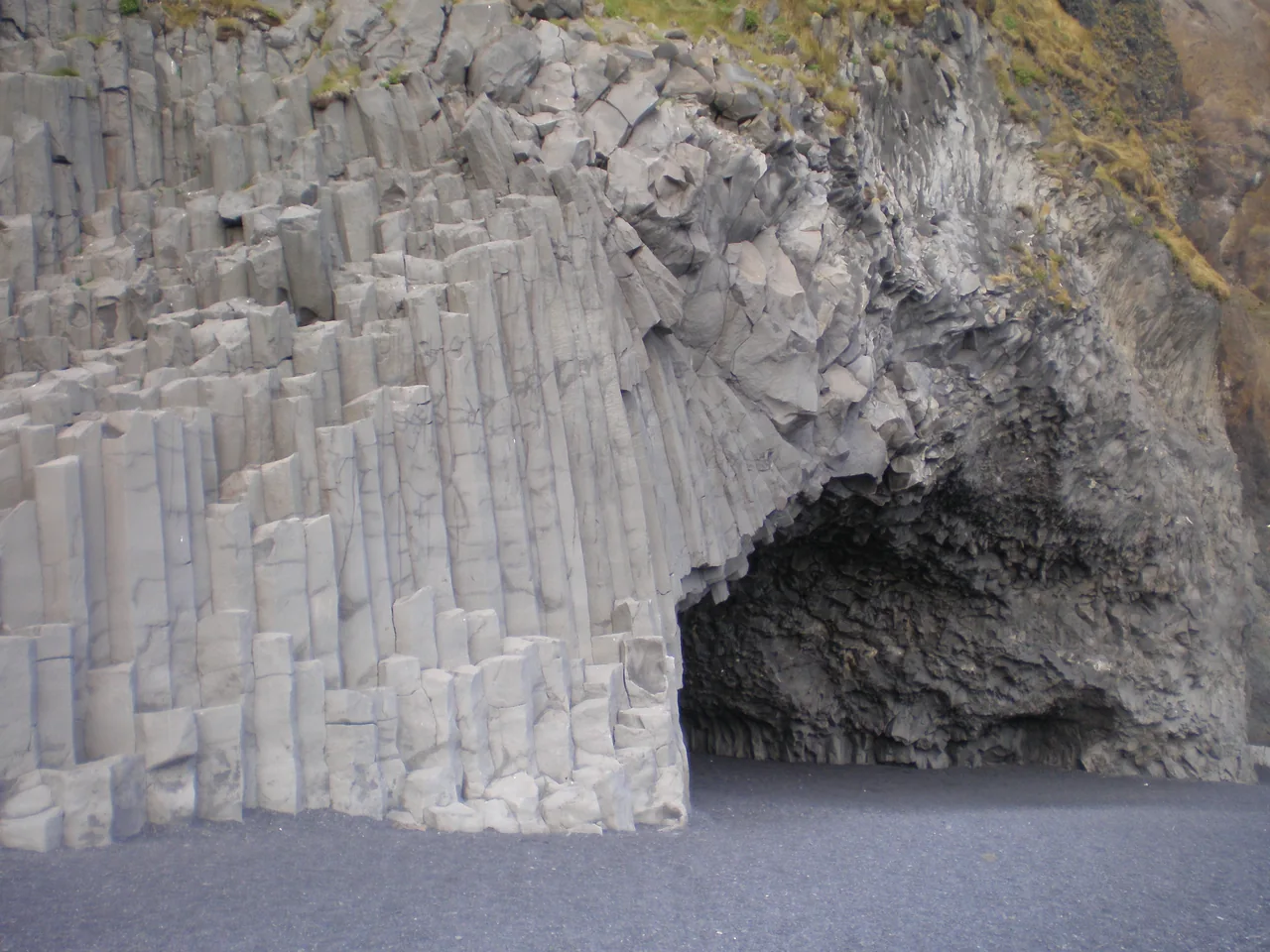
Columnar basalt is striking because its repeated forms can look designed. Let that observation lead to a geological question rather than a claim that the formations are unexplained. A guide or visitor-centre display can make the process easier to understand without requiring you to stand beside the columns. The scale of the repetition is visible from farther away; close contact is not a condition of appreciating it.
Black sand has a different visual effect. It simplifies the colour palette and makes surf, weather and light appear unusually graphic. That is part of the attraction for photographers, but a clean composition can hide the complexity of the surface. What looks like a stable strip in a photograph may be a recently rearranged margin of sediment. Its appearance says little about where a visitor should walk.
Use the geological story to widen the frame. Notice the mountain as a whole, the relationship between cliff and water, and the way offshore forms stand apart from the land. These observations remain available even when the closest approach is restricted. The purpose is not to collect a specimen or prove how near you went. It is to leave with a clearer sense of the different processes meeting in one place.
For another way to read southern Iceland’s changing landscape, see Sólheimajökull’s changing glacier landscape. A glacier excursion has different access and equipment requirements from a coastal stop.
The sea stacks are what resisted
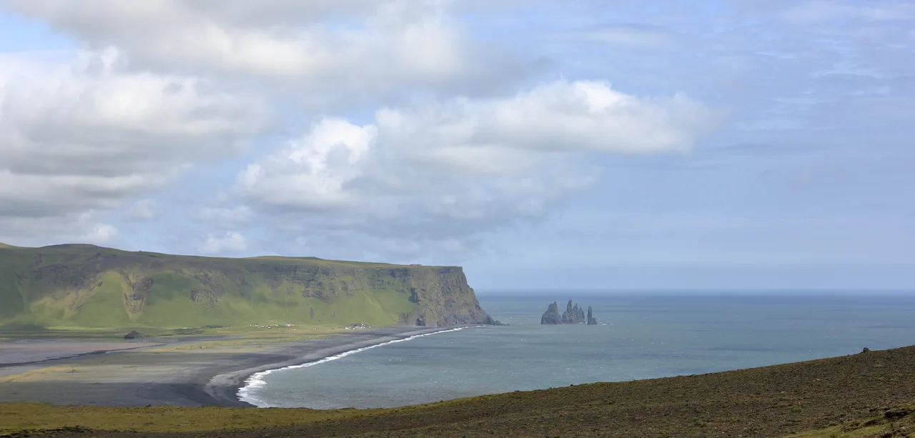
Katla Geopark explains Reynisdrangar as sea stacks formed through erosion of a headland. It describes their bases as columnar basalt, with most of the surrounding tuff having been removed. The stacks are therefore useful evidence of differential resistance: material does not all respond to the sea in the same way. Their separation from the headland is part of the explanation for their dramatic outline. Katla Geopark: Reynisdrangar.
That explanation changes a common way of describing the scene. The stacks do not need to be presented as objects mysteriously placed in the sea. They can be understood in relation to a landscape that has lost surrounding material. A gap becomes as informative as a solid form. The view contains both what remains and the space made by what has gone.
From an authorised viewing position, compare the stacks' silhouettes and their relationship to the coast. A longer lens or a careful crop can isolate the shapes without bringing you closer to the water. If conditions or visibility limit the view, accept that as part of the day. There is no obligation to keep changing position until the image matches a more favourable photograph taken in another season.
Local stories can add another kind of meaning, but folklore and geology should be labelled as different ways of talking about a place. If a guide tells a story about the stacks, ask where that version comes from and how the names are used locally. Do not publish an unattributed legend as an account of what residents universally believe. A story can be interesting without being treated as a scientific explanation.
The name itself is worth recording accurately. Reynisfjara is the beach, Reynisfjall the mountain and Reynisdrangar the offshore stacks. Keeping those distinctions makes map searches, photographs and conversations clearer. It also prevents one location's access instructions from being casually assigned to another merely because the names share a beginning.
Read the warning as an instruction, not a forecast to negotiate
SafeTravel warns about both unexpected wave surges and falling rock. Its practical advice includes staying well back, facing the sea, accompanying children and respecting closures. The colour system distinguishes moderate, considerable and severe hazard; it does not include a promise that a beach visit is free of risk. Under a closure, use only the designated area that current instructions permit. Official beach safety guidance.
People have died here; SafeTravel explicitly records that lives have been lost. Its red-light instruction closes the beach while allowing views from the designated viewing area. A lower warning level does not cancel a separate access restriction: the same page currently limits access to the viewpoint even without a red wave alert. Read the closure notice as well as the colour, and do not use an older photograph to decide where you may stand.
Do not invent a personal clearance rule from something you have read online. A distance copied from a condition-specific warning is not a universal safe line for every tide, wave or stretch of shore. A quiet interval is not a signal that the next interval will be the same. Your responsibility is to follow the current boundary, not calculate a more convenient one from a photograph or a few minutes of observation.
Cliffs add another reason to avoid treating every sheltered-looking space as a refuge. Visit South Iceland's geology trail explicitly advises against entering the cave because rock can fall from the ceiling. A cave photograph should therefore be read as a record of a view, not an invitation to reproduce it. The fact that someone previously stood inside does not establish permission or appropriate conditions now. Regional geology-trail guidance.
Before leaving the vehicle, agree on the extent of the visit with your companions. Keep the group together and make it easy for someone to say they want to return. A tour leader's meeting time is not a target that obliges you to stay outside until the final minute. A short look from a suitable place can be enough.
If the permitted area or conditions do not suit your party, leave. You can still learn about the coast in Vík, use a visitor centre or choose another appropriate activity after checking its own conditions. Changing plans is an ordinary part of travelling through a dynamic landscape. It is not evidence that the trip has failed.
Vík’s history puts people back beside the sea
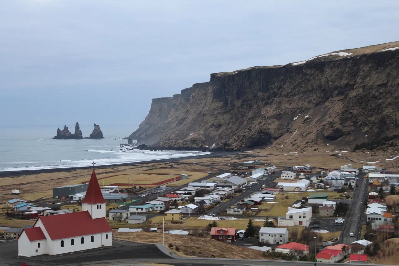
Vík is more than a convenient fuel and food stop beside a famous beach. Katla Geopark describes the settlement's growth around trade for the surrounding district and the challenges of sea transport without a harbour. The ship Skaftfellingur belongs to that history. This is a different relationship with the coast from a brief scenic visit: the sea could be a connection and an obstacle at the same time. Geopark account of Vík.
Visit South Iceland identifies Katla Visitor Centre in the historic Brydebúð building and points visitors toward the area's geological and maritime interpretation. It makes a useful companion to Reynisfjara because it provides names, objects and human decisions that a coastal panorama cannot explain by itself. Confirm current opening times and admission arrangements before relying on it as a timed stop. Katla Visitor Centre information.
A small change in itinerary can make this connection tangible. Instead of leaving the beach and immediately adding another landscape stop, allow time to learn how trade and transport worked in the district. Ask what changed when connections improved, which objects in an exhibition relate to local lives, and how the coast shaped ordinary work. The questions do not require a dramatic story of disaster to be worthwhile.
Outside an exhibition, remember that Vík is a working community. Park where visitors are meant to park, avoid blocking entrances for a photograph and respect businesses' actual hours. A church, residential street or shop is not an extension of a tour's set. If you want a close photograph of someone working, ask rather than assuming the purchase of a coffee includes a portrait.
Language can begin with getting the place names right. Keep Icelandic spellings in your notes where practical, and ask a host to help with pronunciation if they have time. There is no need to turn the interaction into a performance of expertise. Interest is better expressed through a specific question and attention to the answer than through a memorised story about what “all Icelanders” think.
A wool sweater can be a purchase with a story
If you are interested in Icelandic clothing, the lopapeysa offers a useful conversation about materials and making. Iceland's food and veterinary authority, MAST, lists “Íslensk lopapeysa / Icelandic lopapeysa” as a protected product name, approved in 2020. That is a reason to read a garment's description carefully, not assume that every patterned sweater in a souvenir shop has the same origin. MAST protected-name register.
Ask where a garment was made, what fibre it uses, who made it when that information is available and how it should be cared for. Choose something you would genuinely wear. The answer may lead you to a particular maker, or it may simply help you compare products honestly. A more expensive label does not remove the need to understand what is being sold.
For the coast, cultural interest and weather preparation are separate decisions. A wool layer can be part of your clothing system, but a beautiful sweater should not be treated as a substitute for appropriate outer protection. Consider how your layers work together and whether you can adjust them easily between the vehicle, a windy viewpoint and an indoor stop.
You do not need to buy local clothing to be a respectful visitor. The same attention can be expressed by learning about a craft, reading an exhibition label or asking a thoughtful question. Nor should a travel article turn a garment into a costume that supposedly makes its wearer more authentic. Local design is worth understanding on its own terms.
If you photograph a shop display or making process, ask first and keep the maker's name with your notes when they want it credited. That gives a future caption something specific to say. “An Icelandic sweater” is a category; a properly attributed piece of contemporary work is an individual object with a traceable story.
Plan around conditions and daylight
The most useful seasonal question is what the season changes about your journey and time outdoors. A summer itinerary can allow more daylight, while a winter trip may require a tighter route and greater flexibility. Neither season turns an access restriction into a suggestion. Begin with current conditions, then decide how much of the day the stop should occupy.
Separate the driving forecast from the desired photograph. A promising patch of light at the coast is not enough information for the road journey. Check road conditions and weather for the whole route, including the return. If your trip extends beyond Vík, avoid planning the next segment solely from the conditions at the place where you are currently standing.
Winter planning benefits from fewer fixed commitments. Put the most important activity within a realistic daylight window and keep the remainder optional. A meal, a visitor centre or a rest stop can give the day structure when an outdoor visit becomes unsuitable. Do not reserve so many timed activities that a sensible change feels financially impossible.
In a brighter or milder period, retain the same attention to wind, rain and the permitted route. Comfort in the car can make a short stop feel simpler than it is. Have the layers you need accessible before opening the door, and make sure every member of the party has their own essentials rather than expecting to share a single spare jacket.
For photography, accept that the sky belongs to the day you get. Low cloud, strong contrast or a distant view can still communicate the landscape. Plan for an honest image rather than a guaranteed colour palette. If the conditions are not suitable, leave the camera packed and choose another part of the journey. The decision to stop photographing can be the most useful preparation of all.
Find the right coast, then check the road
Use Reynisfjara as the destination name when planning the final approach. A search for “black sand beach” can produce several places, including views from Vík itself. The sea stacks connect these views visually, but a photograph taken from one side does not establish the entrance on the other. Save the actual place name with your route so that the driver, passengers and booking confirmation all refer to the same stop.
The map below marks the Reynisfjara area for orientation. It is not a walking instruction, a parking reservation or evidence that an access path is open. Before setting off, compare the map with the current road information, the site's access notice and the arrangement for your vehicle. An unfamiliar approach deserves attention even if the destination appears in hundreds of itineraries.
Iceland's Road and Coastal Administration directs travellers to Umferðin for road conditions. Check the roads you will actually use, including the onward or return journey. Then check the Icelandic Met Office for the forecast and warnings. Road access, weather and beach access answer different questions; one favourable result does not settle the other two.
Complete those checks with SafeTravel's current beach notice. A road being open means you can assess the journey; it does not mean the shoreline, cave or column area is open. Follow the instructions displayed locally if conditions change after you read the page.
For a self-drive trip, nominate a passenger to handle navigation and saved notices while the driver concentrates on the road. Decide where you will stop for a break before you become tired or distracted. If the journey is running late, shorten the optional sightseeing rather than attempting to recover the time on the road. The beach should fit the day you can reasonably travel.
If you are travelling without a car, ask a prospective tour provider for the exact stop, pickup point and return arrangement. A tour labelled South Coast may include several destinations, with only a short period at each. A stay in Vík does not by itself provide transport to every nearby attraction. Confirm the final connection instead of assuming that a regional bus journey includes it.
Access needs also belong in this conversation. Ask about the current surface, slopes, distance from the vehicle and available toilets. Explain whether you need step-free access, frequent rests or space for mobility equipment. Conditions following erosion may differ from older accessibility descriptions. Specific answers from the operator or site are more useful than a general claim that a place is suitable for everyone.
Price the journey, not just the photograph
A Reynisfjara stop can look inexpensive when it is treated as a pin on a map. The meaningful cost is the portion of your journey that makes the stop possible: vehicle or tour, parking, food and any overnight stay. Work in Icelandic krónur when comparing local quotes. Mixing a hotel amount in euros with parking in krónur produces a number that looks precise without representing a usable budget.
Parking is a separate item to verify. Parka's parking directory includes Reynisfjara, but the relevant zone, vehicle category and current terms must match the place where you park. Read the signs before completing payment. Save the confirmation and check that the vehicle registration is correct. A payment for a different zone does not become valid because the beach name is similar.
This guide does not supply an unverified parking price. Put the amount shown for your vehicle and parking location into the calculator. The same approach applies to optional museums and other paid activities: enter a current quote for the activity you intend to use. A blank field means an expense has not been included; it is not a statement that the service is free.
For a rental car, decide whether you are estimating this outing or your whole South Coast journey. Use the same scope throughout. A share of the rental and fuel may be useful for comparing an outing with a guided tour, while the full rental invoice belongs in the overall trip budget. Add insurance or other contracted charges where they apply, without entering a package component twice.
Meals can be entered per person for this excursion. Accommodation is calculated from rooms, nights and a room price. Two people sharing one room and two people booking separate rooms need different inputs. If you have already paid for breakfast or another meal through your accommodation, include only the additional spending you expect during the outing.
For a guided trip, compare the complete price with the complete self-drive alternative. Check pickup, inclusions and cancellation terms before treating two offers as equivalent. The cheapest headline may represent a shorter stop or a different departure point. Keep a separate allowance for changes to the plan; the calculator describes the costs you enter and cannot predict what a disrupted itinerary will require.
Choose a base with room to change your mind
Vík is a useful place to consider when the coast is one part of a longer South Iceland journey. Staying nearby can give you more flexibility than attaching every stop to a single long day. That does not make an overnight stay essential. Compare the accommodation cost and your wider route with the value of having less driving to fit around this visit.
Read the location carefully when browsing stays. A listing associated with Vík may be outside the settlement; that can change the journey to food, shops or your next stop. Check the actual address, parking arrangements, room configuration and cancellation conditions. If arriving late, confirm check-in arrangements with the property rather than relying on an assumption about reception hours.
For a guided South Coast outing, useful questions are straightforward: Which Reynisfjara access point is planned? What happens if it is restricted? How much of the day is spent travelling? Is there a meal stop? Where will the group return? A clear answer about a replacement stop is more valuable than a promise that every advertised photograph can be recreated.
Be cautious about treating a detailed itinerary as an assurance of access. Conditions can change after a booking is made. Read the operator's terms and decide whether the trip still interests you if Reynisfjara becomes a viewpoint visit or is omitted. If the only reason you want that excursion is a close-up beneath the columns, its appeal rests on access that should not be promised.
The accommodation link below is an ordinary browsing link, without affiliate tracking. It helps you compare stays; it is not a claim that Hidden Corners has inspected the listed rooms. Current beach information remains available through SafeTravel. Booking a room or paying for transport does not alter the site's restrictions.
Dress for an exposed stop, with both hands free
The useful packing question is what you need between leaving the vehicle and returning to it. Keep that kit together rather than burying it beneath luggage for the rest of Iceland. A short stop can still involve wind, rain and a wait outdoors, particularly when the group is moving at different speeds. Put on the layers you need before starting the walk.
Build clothing around an insulating layer and an outer layer suitable for the forecast. A hood, secure hat and gloves may be more practical than trying to hold several loose accessories. Choose footwear for the actual surface and conditions, with a secure fit. If conditions require equipment or skills you do not have, change the outing rather than treating an extra item as permission to proceed.
An Icelandic wool sweater can be an enjoyable purchase and a useful warm layer when it suits you. It is not a required costume, and it should not be confused with a waterproof outer layer. If you buy one, ask about the maker, material and care instructions. The cultural story of a garment is more interesting when it remains attached to its actual production.
Keep a phone, essential contact information and your route available offline. Protect electronics from rain and carry only the camera equipment you can manage comfortably. A shoulder bag that swings forward or an unsecured lens cap becomes an unnecessary distraction. Before lifting a camera, choose a position within the permitted area where you can keep awareness of people and conditions around you.
A zoom lens, if you already use one, can help isolate the stacks or a distant texture from an authorised viewpoint. It is optional; a wide scene can communicate the relationship between cliff, coast and sea more clearly. Do not move toward a restricted edge to compensate for the limits of your equipment. The photograph should follow the available position.
For families, give each person appropriate clothing and agree on staying together before leaving the vehicle. Keep children's spare layers easy to reach. Plan food and a warm break around the outing rather than assuming everyone will remain comfortable until the next scheduled destination. When someone needs to return, a shorter visit is a reasonable outcome.
Carry your personal essentials, drinking water and a way to take your own litter away. Leave room in the bag instead of filling it with accessories for every possible photograph. A small, manageable kit helps you give the place more attention. No clothing or camera accessory removes the need to follow closures and current instructions.
A coast-and-village day, with an indoor alternative
Start with three decisions: whether the journey is suitable, what the current site permits and what you would enjoy if the beach stop is shortened. These decisions create a more resilient day than a sequence of fixed photo appointments. They also give everyone in the party the same expectation before the first journey begins.
If the viewpoint visit is suitable
Arrive with the current access information already read, then follow the signs and instructions on site. Use the permitted view to identify the main relationships: the mountain behind the beach, the stacks offshore and the changing strip between land and sea. You do not need to identify every rock type to recognise that construction and erosion have both shaped the scene.
Give the visit a single observation task. Compare the outline of the stacks with the broader headland, or look at how the shoreline changes direction across the view. Photograph the relationship first, then any detail you can frame from the same permitted position. This approach produces a small set of connected images rather than a collection of unrelated close-ups.
Continue to Vík for a break and, if open, the Katla visitor centre. Its geological and cultural material gives names and context to features that can be difficult to understand outdoors. Ask about the exhibitions currently available and the maritime collection. The shift from coast to village connects a landscape visit with the practical history of people living beside that sea.
If access or weather changes the plan
Choose the indoor part first, provided the journey itself remains suitable. A museum visit, a meal and time with a regional map can become the main outing. Avoid replacing one restricted coastal stop with an improvised search for a quieter shore. Fewer people and fewer signs do not establish better conditions.
If the road journey is unsuitable, keep the alternative closer to your accommodation. Contact any affected provider using the arrangements in your booking. A flexible itinerary is useful only when you act on the flexibility; keeping every reservation at all costs defeats its purpose. The landscape will continue changing whether you see it that afternoon or another time.
Make a useful record
After the visit, note the date, named viewpoint and any relevant access limitation with your photographs. That context matters here because an attractive image can circulate long after its route is unavailable. If you share a picture, describe the view you were permitted to use. Avoid turning an old photo of the shoreline into current directions for someone else's trip.
If you are considering a separate Sólheimajökull viewpoint and glacier visit, use its access advice before deciding what belongs in the day. Do not treat an ice excursion as an unplanned roadside detour.
Three ways to understand the island behind the beach
Begin locally. Katla Geopark's descriptions of Reynisfjall and Reynisdrangar provide a manageable geological introduction, while the visitor centre connects the district's natural history with settlement and work. Read one landform description before looking at a photograph. Then ask which part of that explanation is visible and which part depends on geological interpretation.
For wider history, How Iceland Changed the World by Egill Bjarnason offers a national perspective, according to its publisher's description. It is a way to place a short South Coast visit within a larger human story. It should not be treated as a source for the current parking arrangement or this week's access conditions.
Island on Fire, by Alexandra Witze and Jeff Kanipe, follows the Laki eruption of 1783 and its wider consequences. Its subject is distinct from Reynisfjara's immediate geology. That distinction makes it useful: reading about one documented eruption can help you resist treating every Icelandic landform as the product of the same event. Check the edition and available formats through the publisher.
The third suggestion is a free reading route through Katla Geopark's local pages rather than another purchase. Move from the mountain to the sea stacks and then to Vík. This sequence follows the article's own question: how does a landscape become both a physical place and the setting for everyday life? Save the pages you need before travelling.
These suggestions are based on the publishers' descriptions and the named public resources, not a claim that our team has reviewed every page of each book. Choose the depth that interests you. A short introduction read attentively can contribute more to a visit than carrying several unread volumes.
The questions that change this visit
Can I still get a worthwhile view without walking on the beach?
The landscape includes relationships visible at a distance: stacks separated from the coast, a mountain shaped by different materials and a shoreline that changes. A viewpoint visit can be worthwhile for those subjects. Whether it meets your personal expectations depends on what you hoped to see. Check the permitted access before committing to a journey built around a particular close-up.
Does a photo of people beside the columns mean that route is available?
No. A photograph records a scene at a particular time and does not necessarily document permitted behaviour even then. The dated pictures in this guide illustrate the place; they do not replace current access instructions. Use the latest official notice and on-site information to decide where you may go.
Should I visit Reynisfjara or spend more time in Vík?
They answer different interests and can complement each other when the journey and conditions allow. Reynisfjara provides the coastal setting; Vík offers a way into the district's settlement, maritime history and present-day services. With limited time or restricted access, choose the part that is both feasible and most useful to you rather than rushing through both.
Do I need an expensive camera or specialist clothing?
You need clothing appropriate to the actual conditions and a visit within your abilities. Expensive equipment is not a requirement for understanding the view. A phone photograph from a permitted position can document the same broad relationships. Spend attention on preparation and observation before adding purchases to the trip.
What is the hidden corner in such a famous place?
It is the distance between a fixed image and a coast that continues to change. Reynisfjara is often recognised before it is understood. The layers in the mountain, the remaining stacks and the history of a harbourless settlement give the familiar view more substance. Leave with a photograph if conditions allow, but keep the date and the story attached.
A closer look.
Three dated views explain the coast, column detail and nearby settlement. They show historical appearances, not current access routes.

Sok Heng Oeun
Sok Heng Oeun is the owner and editor of Hidden Corners. The Hidden Corners Editorial Team supports image preparation and editorial checks under his direction.
Sok Heng Oeun on Facebook ↗Research and AI-assisted editorial preparation. Publication authorized by Sok Heng Oeun; an individual owner reading review is not recorded. This guide does not claim a firsthand team visit.
Sources & image credits
Sources supporting this guide. Dated prices and access reports can change; confirm with the responsible authority before travelling.
- Check Reynisfjara access on SafeTravel ↗
- Tourist Board erosion notice ↗
- March update, in Icelandic ↗
- Katla Geopark: the local reading route ↗
- Katla Geopark: Reynisdrangar ↗
- Regional geology-trail guidance ↗
- Geopark account of Vík ↗
- Katla Visitor Centre information ↗
- MAST protected-name register ↗
- Umferðin for road conditions ↗
- Icelandic Met Office ↗
- Parka's parking directory ↗
- How Iceland Changed the World — Egill Bjarnason ↗
- Island on Fire — Alexandra Witze & Jeff Kanipe ↗
Photograph credits
- Reynis Coast · Martin Falbisoner · 2014-07-20 · CC BY-SA 4.0. Resized and converted to WebP; display may crop to fit. These adaptations remain available under their respective licences.
- Reynis Vik · Nihcolas Babaian · 2018-02-27 · CC BY-SA 4.0. Resized and converted to WebP; display may crop to fit. These adaptations remain available under their respective licences.
- Reynis Columns · diego_cue · 2009-08-10 · CC BY-SA 3.0. Resized and converted to WebP; display may crop to fit. These adaptations remain available under their respective licences.
Packing and outfit graphics: AI-generated editorial illustrations. Portrait: supplied by Sok Heng Oeun.

.jpg)
_(2).jpg)
